
2026-27 Board of Directors |
Officers |
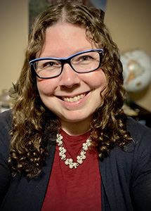
| Courtney Dobbertin, President
Courtney Dobbertin is honored to serve as your 2026-2027 Women in GIS President! An active member in the Wednesday Communities of Practice and part of the Tampa Bay Chapter of WiGIS’s event committee, Courtney is all about making a strong, safe, and empowered GIS community for women+ and marginalized folks. She is a GIS Analyst with Pinellas County, FL Water Utilities, supporting Plant Operations on the Operations, Solutions, and Innovations (OSI) team. When they aren’t championing and cheering on women and marginalized folks in the GIS & STEM communities, Courtney is a mentor for young neurodivergent individuals, reading from her never-ending TBR list, and is a volunteer diver at the Florida Aquarium.
|

| Stefanie Von Flue, Vice PresidentStefanie (Stevie) Von Flue is an engineering technician with nearly 24 years of experience supporting the mining, civil, and geological engineering consulting industry. When she is not supporting engineers and geologists, she is volunteering with a local non-profit riparian organization or the local food bank, running the western Colorado roads, reading, or hiking and camping with her partner and dogs. |

| Wanmei Liang, Past PresidentWanmei Liang works at NASA Earth Observatory as a Science Data Visualizer, specializing in cartography, science communication, GIS, and remote sensing to produce maps and satellite imagery for NASA's Image of the Day. Beyond her professional role, Wanmei is a passionate advocate for promoting diversity and inclusion in the geospatial field, particularly through her commitment to Women in GIS. Since August 2022, she has been a consistent presence at every Communities of Practice, Mugs and Mornings, and virtual gatherings across all chapters. In addition to her involvement in Women in GIS, she engages with a global audience through her active online presence, in which she shares her geospatial journey and cartography skills. Wanmei is honored to continue her journey with Women in GIS as Vice President, driving the organization's expansion and inclusivity. With her passion, experience, and dedication, she is committed to empowering others and shaping a vibrant future for Women in GIS. |

| Samantha Dinning, SecretarySam began attending events through the Arizona Chapter in 2020 and became an active member of Women in GIS in 2021. She participated as a mentee which led to being involved in the Outreach & Map Committees, and WiGIS events. She co-founded the Colorado Chapter in 2022. She served as Vice President, President, and Past President from 2022-2025. Sam currently lives in AZ and she is excited to continue serving on the board as Secretary! |

| Elizabeth Houser, Treasurer
Beth Houser has been a GIS professional since 2007. She earned a BS in Environmental Science and a MS from UPenn in Urban Spatial Analytics, focusing on land use and planning. Beth began her career at a regional planning commission, and since 2009, has been the GIS Specialist at WRT, a planning and architecture firm. Working to design communities to be more resilient and equitable, she gets the opportunity to analyze and portray data at differing scales across the US. She served for four years as Treasurer for the Chester County Mothers of Multiples club and is excited to be able to serve the WiGIS community in a similar capacity. During Beth’s “spare” time, she enjoys spending time with her four children, reading, playing board games, gardening, and camping.
|
Committee Chairs |
| Awards & Scholarship: Devika JainDevika Jain is a Data Science Manager at the Center for Geographic Analysis (CGA), Harvard |

| Chapters: Jennifer Parmeley
Jen Parmeley, GISP, is a geospatial advocate with over 20 years of experience in GIS and geographic education. She joined Women in GIS in 2022 on a whim and it was love at first COP meeting. She's built an informal Nebraska chapter of Women in GIS to bring this support to her local community and is so excited to be filling in as Interim Chapters Chair. Experience Builder days are her favorite days at work, Arcade might be her love language, and she is a firm believer in Metadata Mondays (and topology!). In her free time you can find her knitting and chatting in the Crafts & Chats meetups.
|

| External Engagement: Susan Muleme KasumbaSusan has over 25 years of experience in the geospatial industry and is currently the Director of Business Development at Forsite, formerly Barr GeoSpatial Solutions, where she specializes in creating LiDAR solutions for clients across government, engineering, utilities, renewable energy, mining, and forestry. A graduate of Sir Sandford Fleming’s GIS/Cartography program and an attendee of the University of Guelph, she began her career in GIS software technical support, cartography, and photogrammetric mapping before transitioning into sales and business development.
Beyond her professional work, Susan is dedicated to mentoring and industry advocacy. She served for 10 years on the board of BeSpatial Ontario, launching a mentorship program as President to support new professionals entering the field.
As Chair of External Partnerships, she actively connects with industry partners and sponsors to maximize engagement and value for our members. |

| Internal Affairs: Jennifer ZumbadoJennifer Zumbado-Hannibal, GISP, is a Geographic Information Systems Professional with over 20 years of experience in geospatial data management and GIS technology implementation. She serves as the Geographic Information Systems Coordinator for the City of Forest Grove, Oregon. Her expertise includes designing enterprise-level geospatial databases, developing GIS web applications, and automating workflows with Python. A collaborator in Washington County's GIS Infrastructure Group, she has helped standardize data protocols and secured funding for aerial photography and LIDAR missions to support infrastructure and disaster response planning. Jennifer holds a Master of Science in Environmental Sciences and a Bachelor of Science in Geography from Florida Atlantic University, specializing in GIS and Remote Sensing. She is fluent in Spanish and actively participates in GIS organizations, including serving on the board of ORURISA (2019-2021). Jennifer is passionate about diversity and inclusion in GIS, particularly advocating for neurodivergent representation. Her commitment to collaboration, innovation, and diversity in the GIS community is evident throughout her career. |

| Mentorship: Savannah JustusSavannah Justus is a GIS Analyst working at the Indiana Department of Emergency Management. She has earned an MS in GIS from Kent State University and has her FAA Part 107 UAV license. She has GIS experience in local and state government, public safety, GIS administration, and developing web applications. Savannah volunteers in other GIS organizations such as the Indiana GIS Day Planning Committee and Indiana Geographic Information Council (IGIC), while previously serving on the conference planning committee in the Tennessee Geographic Information Council (TNGIC). Savannah is passionate about expanding access to the GIS field and excited to help grow that mission through improving mentorship opportunities for women. She is very excited to work with the wonderful volunteers on the Mentorship Committee and continue to grow the Women in GIS mentorship program. |

| Outreach: Julia ReisemannJulia Reisemann is an experienced GIS professional with over 27 years of expertise in data analysis, mapping, and developing workflows that make geospatial tools accessible across disciplines. As GIS Manager at 3J Consulting, a civil engineering and community planning firm based in the Pacific Northwest, she leads the collection, analysis, and application of geographic data to support planning and infrastructure projects for communities throughout the United States. Over the course of her career, Julia has partnered with planners, engineers, and public agencies to solve complex challenges through data-driven approaches. |

| Professional Development: Rupsa Roy
I'm a Senior Project Scientist using GIS, data science, and climate modeling to support
resilience, equity, and sustainability. I work with communities on urban heat, flooding, and environmental justice. I'm passionate about mentoring women in STEM, data storytelling, and inclusive growth. I'm excited to bring my skills and leadership to Women in GIS and help empower others through professional development. I’m passionate about creating inclusive spaces where women in GIS can grow, lead, and thrive. I bring over a decade of experience using geospatial tools to address climate resilience, equity, and sustainability. I’ve led collaborative projects with communities and agencies, and I’m committed to mentoring and uplifting others in our field. I would bring strong leadership, technical expertise, and a deep dedication to empowering diverse voices through professional development. |
